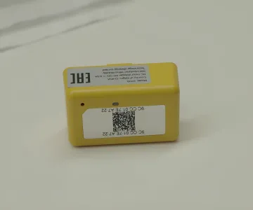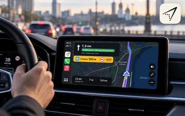

Yandex has developed a compact on-board device called Compass, designed to more accurately determine a vehicle's location and direction of movement under conditions of unstable satellite geolocation services. The novelty is already undergoing testing in 10,000 taxi cabs, and drivers and taxi fleets can receive the device free of charge. According to the engineers' design, Compass addresses one of the most frequent problems in urban navigation—the car "jumping" across the map when the GPS signal degrades in tunnels, underground parking lots, or dense high-rise developments.
How Compass Is Built and Where It Gets Data
The device connects to the vehicle's diagnostic port, namely the CAN bus, and receives wheel rotation speed data from it. Built into the design are a gyroscope and an accelerometer, which help determine the direction of movement. The data collected by the sensors is transmitted via a Bluetooth module to the Yandex Pro app, where drivers themselves can see it. A special algorithm combines and analyzes all incoming information, compares it with the latest geolocation signals and Wi-Fi hotspot data from the smartphone, which allows for more accurate online determination of the vehicle's coordinates.
Why the Solution Was Built Primarily for Taxis
"During geolocation failures, a car can 'jump' across the map—we receive thousands of requests to support services asking to help find the driver. We started developing the solution primarily for taxis because here every trip depends on exact coordinates—from the driver receiving the order to route calculation. Already at the testing stage, we see that Compass helps reduce order cancellations caused by passengers and drivers not being able to find each other," said Alexander Malayrey, head of the Yandex Compass project. Thus, coordinate accuracy directly affects the economics of the trip: fewer "lost" drivers mean fewer cancellations and complaints.
Inertial Navigation and Differences from a Smartphone
Inertial navigation is engaged in cases where geolocation data may be inaccurate—for example, in tunnels, underground parking lots, and other "dead zones." In such conditions, the vehicle's position is calculated from the last successful geolocation point based on speed and direction of movement, while geolocation data and Wi-Fi access points are used to reduce errors. Standard navigation apps also rely on the accelerometer, gyroscope, and magnetometer inside the smartphone, but their readings can change when the phone's tilt angle changes. Compass lacks this disadvantage: it is rigidly fixed in the car and receives data directly from it, rather than from a device being moved around in the hand.
Fully Proprietary Development and Future Plans
Yandex emphasizes that Compass was developed entirely by its own engineers—including technical configurations, firmware, and algorithms used. In the future, the company plans to expand the areas of application for the device and develop other products in the inertial navigation segment, including for private car owners. This fits into a broader trend of increasing the reliability of Yandex's navigation services: in parallel, the company is refining its Maps app, teaching it to plot routes and guide users in a completely offline mode without an internet connection, which is especially relevant in regions with unstable mobile coverage.